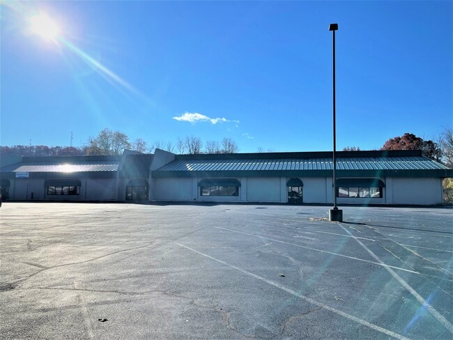
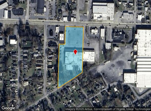
Property Record
2000 W State St, Bristol, TN 37620
NEARBY LISTINGS FOR SALE OR LEASE
Property Detail
2000 W State St
020C-B-014.00
DISTRICT: 17, COUNTY AREA: A30
Bowlingalley
Sullivan
X
Tennessee
47163C0102E
4.41 AC
0
Sullivan County
2024
Kingsport/Bristol/Bristol
042703
Kingsport-Bristol, TN-VA
53,481 SF
DEMOGRAPHICS near 2000 W State St
1 Mile
3 Mile
5 Mile
2024 Total Population
6,398
31,966
52,093
2029 Population
6,606
32,754
53,213
Pop Growth 2024-2029
+ 3.25%
+ 2.47%
+ 2.15%
Average Age
42
42
43
2024 Total Households
2,889
14,151
22,788
HH Growth 2024-2029
+ 3.25%
+ 2.49%
+ 2.15%
Median Household Inc
$31,519
$38,440
$45,488
Avg Household Size
2.10
2.20
2.20
2024 Avg HH Vehicles
2.00
2.00
2.00
Median Home Value
$79,038
$131,946
$147,206
Median Year Built
1959
1961
1969
Nearby Places
Map Layers
Map Styles
 Street
 Aerial
- Restaurants
- Banks
- Shops
- Fitness
- Groceries
PUBLIC TRANSPORTATION
AIRPORT
Tri-Cities
DRIVE
WALK
Distance
Tri-Cities
25 min
16.8 mi
Freight Ports
Virginia Port Authority - Richmond
DRIVE
WALK
Distance
Virginia Port Authority - Richmond
371 min
331.8 mi
SALE & LEASE HISTORY
LISTING DATE
SALE/LEASE

Nov 22, 2021
For Sale
Nearby Properties
Address
Land Use
TOTAL SIZE
Lot Size
Zoning
Address
Land Use
TOTAL SIZE
Lot Size
Zoning
571,262 SF
37.48 AC
Address
Land Use
TOTAL SIZE
Lot Size
Zoning
296,552 SF
22.10 AC
Address
Land Use
TOTAL SIZE
Lot Size
Zoning
99,923 SF
17.39 AC
A1
Address
Land Use
TOTAL SIZE
Lot Size
Zoning
98,152 SF
33.16 AC
Address
Land Use
TOTAL SIZE
Lot Size
Zoning
16.10 AC
Address
Land Use
TOTAL SIZE
Lot Size
Zoning
53,840 SF
2.86 AC
Address
Land Use
TOTAL SIZE
Lot Size
Zoning
18,560 SF
13.79 AC
Address
Land Use
TOTAL SIZE
Lot Size
Zoning
29,760 SF
0.69 AC
Address
Land Use
TOTAL SIZE
Lot Size
Zoning
43,121 SF
0.34 AC
Address
Land Use
TOTAL SIZE
Lot Size
Zoning
56,822 SF
5.09 AC
Address
Land Use
TOTAL SIZE
Lot Size
Zoning
53,350 SF
1.25 AC
Address
Land Use
TOTAL SIZE
Lot Size
Zoning
81,150 SF
6.18 AC
Address
Land Use
TOTAL SIZE
Lot Size
Zoning
13,316 SF
6.45 AC
Address
Land Use
TOTAL SIZE
Lot Size
Zoning
131,928 SF
9.24 AC
Address
Land Use
TOTAL SIZE
Lot Size
Zoning
85,950 SF
5.03 AC
PBD
Address
Land Use
TOTAL SIZE
Lot Size
Zoning
89,804 SF
10.20 AC
Address
Land Use
TOTAL SIZE
Lot Size
Zoning
12.04 AC
Address
Land Use
TOTAL SIZE
Lot Size
Zoning
116,100 SF
1.73 AC
Address
Land Use
TOTAL SIZE
Lot Size
Zoning
93,509 SF
1.58 AC
Address
Land Use
TOTAL SIZE
Lot Size
Zoning
16,228 SF
7.92 AC
Address
Land Use
TOTAL SIZE
Lot Size
Zoning
43,483 SF
1.25 AC
Address
Land Use
TOTAL SIZE
Lot Size
Zoning
25,670 SF
0.62 AC
Address
Land Use
TOTAL SIZE
Lot Size
Zoning
26,696 SF
2.38 AC
Address
Land Use
TOTAL SIZE
Lot Size
Zoning
101.72 AC
A1
Address
Land Use
TOTAL SIZE
Lot Size
Zoning
31,269 SF
1.22 AC
Address
Land Use
TOTAL SIZE
Lot Size
Zoning
108,832 SF
4.63 AC
Address
Land Use
TOTAL SIZE
Lot Size
Zoning
61,362 SF
7.82 AC
Address
Land Use
TOTAL SIZE
Lot Size
Zoning
10,628 SF
6.19 AC
Address
Land Use
TOTAL SIZE
Lot Size
Zoning
68,719 SF
12.63 AC
Address
Land Use
TOTAL SIZE
Lot Size
Zoning
59,506 SF
10.41 AC
The World's #1 Commercial Real Estate Marketplace
Connect with us
© 2026 CoStar Group
The information above has been obtained from sources believed reliable. While we do not doubt its accuracy we have not verified it and make no guarantee, warranty or representation about it. It is your responsibility to independently confirm its accuracy and completeness. Any projections, opinions, assumptions, or estimates used are for example only and do not represent the current or future performance of the property. The value of this transaction to you depends on tax and other factors which should be evaluated by your tax, financial, and legal advisors. You and your advisors should conduct a careful, independent investigation of the property to determine to your satisfaction the suitability of the property for your needs.